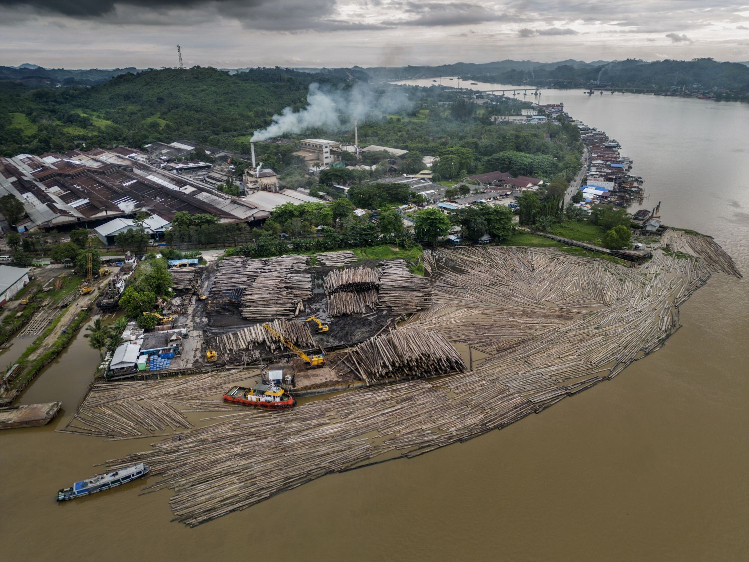
 East Kalimantan, on the Mahakam river between Samarinda and Tenggarong, Cranes unloading wood from a barge on the Mahakam river.
 2023 Deforestation by the Wood Pulp Industry in Indonesia Surges, Hits Record Highs in Kalimantan
East Kalimantan, on the Mahakam river between Samarinda and Tenggarong, Cranes unloading wood from a barge on the Mahakam river. Rising global demand for wood pellets, wood pulp, viscose for clothing, paper, tissue and packaging is fueling a new wave of expansion in Indonesia, especially in Kalimantan, the Indonesian part of Borneo.
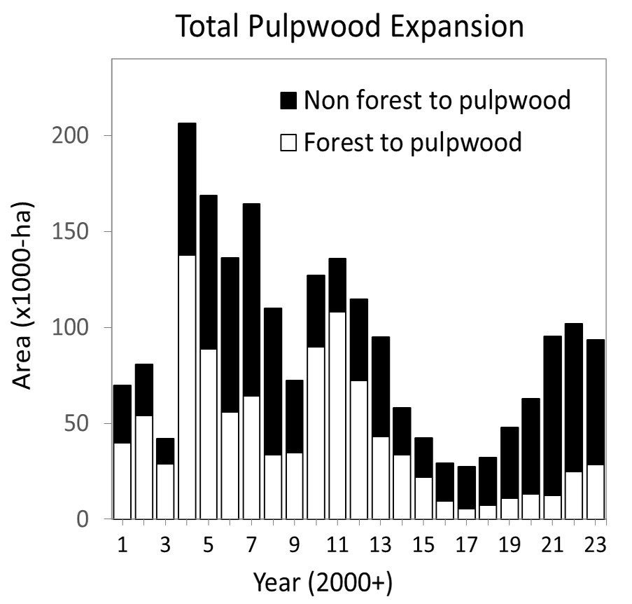
In 2023, the conversion of Indonesian primary1 forests into fast-growing, intensively managed monoculture pulpwood plantations (mostly Acacia sp. or Eucalyptus sp.) saw another increase over the previous year.
Our study, utilizing Sentinel-2 and Planet/NICFI satellite imagery, reveals that 28,000 hectares of primary forest were converted to pulpwood plantations in 2023, representing a 15% increase from 2022, as illustrated by the white bars in Figure 1.
The amount of peatlands converted, remained stable with 26,694 ha cleared in 2023 compared to 26,997 ha cleared in 2022 (white bars; Figure 2).

In 2023, Kalimantan, plantation area increased by 74,000 hectares, a 12% growth from 2022, as shown in Figure 3. This expansion led to the conversion of 27,000 hectares of primary forest, a 13% increase from the previous year, representing 95% of Indonesia’s deforestation caused by pulpwood production.
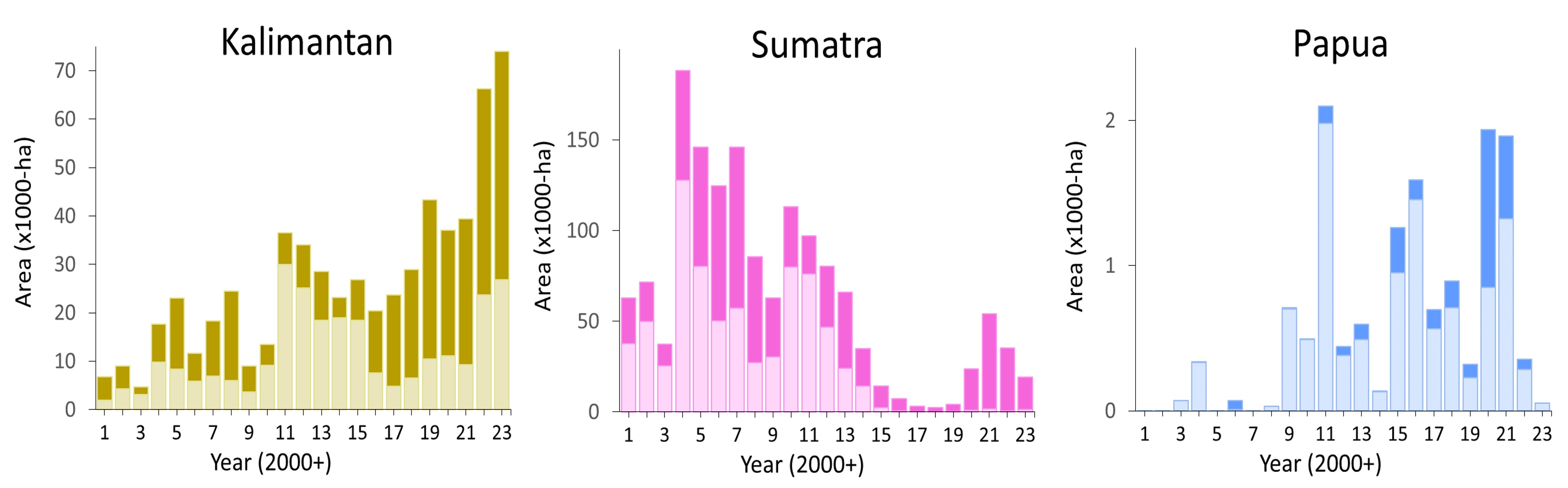
Peatlands conversion in Kalimantan also increased, with 15,585 ha cleared (Figure 4), a 79 % increase since 2022 (8,727 ha converted).
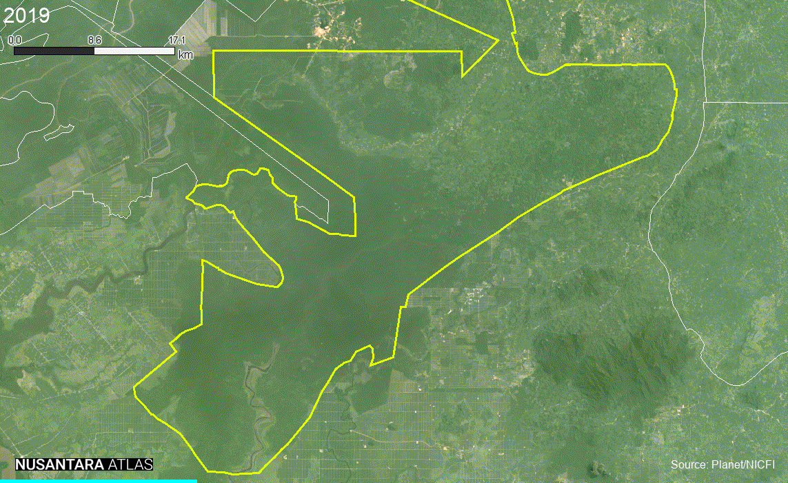
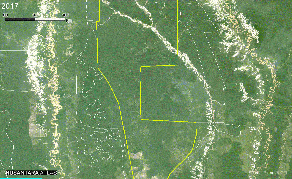
Notably, 80% of the deforestation in 2023 took place in just two concessions: Mayawana Persada and Industrial Forest Plantation.
Mayawana Persada alone accounted for 57% of the deforestation, highlighting its disproportionately large impact.
This trend is consistent with the previous years. Between 2019 and 2022, these two companies cleared >40,000 hectares of prime orangutan forest habitat.
The ultimate beneficial owners of Mayawana Persada and Industrial Forest Plantation are concealed because their ownership is distributed among undisclosed companies based in tax havens like the British Virgin Islands and Samoa.
However, a recent investigation indicates that Industrial Forest Plantation is linked to APRIL/Royal Golden Eagle (RGE).
Using tracking devices, another investigation determined that the forest cleared and pulpwood trees grown in the concession of Industrial Forest Plantation are processed in China by two subsidiaries of APRIL/RGE: Asia Symbol and Sateri.
Along with Asia Pulp & Paper (APP), APRIL/RGE leads in Indonesia’s pulp production and exports, channelling almost three-quarters of the country’s pulp exports to China.
APRIL/RGE currently supply a quarter of the world’s viscose, to the clothing and home goods sector through its Chinese and Indonesian subsidiaries.
Tables 1 and 2 present a comprehensive list of companies involved in converting forests and peatlands into industrial wood pulp plantations in 2023. Each of these companies is catalogued in the Nusantara Atlas, where users can view satellite animations to independently verify the changes.
Table 1. List of companies converting forest to industrial monoculture acacia and eucalyptus plantations in 2023. This table only shows conversion >50 ha.
| No | Company Name | Group | Concession (Ha) | Province | Deforestation | |
| 1 | Mayawana Persada | Alas Kusuma | 138,809 | West Kalimantan | 16,118 | |
| 2 | Industrial Forest Plantation | Nusantara Fiber | 101,416 | Central Kalimantan | 3,781 | |
| 3 | Jaya Bumi Paser | 23,597 | East Kalimantan | 2,476 | ||
| 4 | Sendawar Adhi Karya | 24,077 | East Kalimantan | 640 | ||
| 5 | Baratama Putra Perkasa | 36,038 | Central Kalimantan | 590 | ||
| 6 | Intraca Hutani Lestari | 41,611 | North Kalimantan | 553 | ||
| 7 | Hutan Rindang Banua | Sinar Mas Group (UFS-DSS) | 247,618 | Kalimantan Selatan | 465 | |
| 8 | Bumi Hijau Prima | 20,533 | Central Kalimantan | 349 | ||
| 9 | Grace Putri Perdana | 29,221 | Central Kalimantan | 282 | ||
| 10 | Swadaya Perkasa | 16,694 | East Kalimantan | 253 | ||
| 11 | Muara Sungai Landak | 11,847 | West Kalimantan | 196 | ||
| 12 | Buana Megatama Jaya | 43,111 | West Kalimantan | 119 | ||
| 13 | Indosubur Sukses Makmur | 28,215 | East Kalimantan | 113 | ||
| 14 | Fajar Wana Lestari | 17,697 | West Kalimantan | 101 | ||
| 15 | Bumi Persada Permai (Sk 79) | Sinar Mas Forestry Affiliated | 24,706 | South Sumatra | 76 | |
| 16 | Hutan Berau Lestari | 12,298 | East Kalimantan | 75 | ||
| 17 | Siemon Agro | 10,161 | Central Kalimantan | 74 | ||
| 18 | Limbah Kayu Utama | 19,549 | Jambi | 66 | ||
| 19 | Sumatera Riang Lestari | RAPP supply partner | 173,918 | Riau | 64 | |
| 20 | Selaras Inti Semesta | Medco | 166,751 | Papua | 55 | |
| 21 | Bukit Raya Mudisa | RAPP supply partner | 28,004 | West Sumatra | 54 |
Table 2. List of companies converting peatlands to industrial monoculture acacia and eucalyptus plantations in 2023. This table only shows conversion >50 ha.
| No | Company Name | Group | Concession (Ha) | Location | Clearing on peat | |
| 1 | Mayawana Persada | Alas Kusuma | 138,809 | West Kalimantan | 13,528 | |
| 2 | Bumi Mekar Hijau | Sinar Mas Forestry Affiliated | 250,272 | South Sumatra | 2,509 | |
| 3 | Buana Megatama Jaya | 43,111 | West Kalimantan | 1,728 | ||
| 4 | Sumatera Riang Lestari | RAPP supply partner | 173,918 | Riau | 1,024 | |
| 5 | Satria Perkasa Agung (Sk 244) | Sinar Mas Forestry | 76,778 | Riau | 375 | |
| 6 | Sekato Pratama Makmur | Sinar Mas Forestry Affiliated | 45,980 | Riau | 317 | |
| 7 | Muara Sungai Landak | 11,847 | West Kalimantan | 238 | ||
| 8 | Bumi Andalas Permai | Sinar Mas Forestry Affiliated | 189,529 | South Sumatra | 50 | |
| 9 | Tri Pupajaya | Sinar Mas Forestry Affiliated | 21,583 | South Sumatra | 26 | |
| 10 | Baratama Putra Perkasa | 36,038 | Central Kalimantan | 23 | ||
| 11 | Seraya Sumber Lestari | RAPP supply partner | 19,672 | Riau | 20 |
(1) Our definition of ‘Primary forest’ includes intact primary forests as well as primary forests that have been degraded by selective timber harvesting during the 1980s and 1990s. Intact forests have not been severely disturbed by humans in recent decades, or disturbances were too old to be detected by the satellites. Selectively logged forests include forests that have been impacted by both artisanal tree cutting as well as by more extensive mechanized timber cutting and extraction. A comparison against available above-ground biomass and tree height maps indicates a mean ± SD above-ground carbon of 116 Mg C/Ha and mean ± SD tree height of 28 ± 11 metres for ‘Primary forests’. Intact and selectively logged forests are similar to “primary” and “secondary” forests on the Indonesian Ministry of Forestry and Environment’s forest maps. Our definition of “forests” excludes young forest regrowth, agro-forests, mixed gardens, scrublands, tree plantations, agricultural land, and non-vegetated areas.