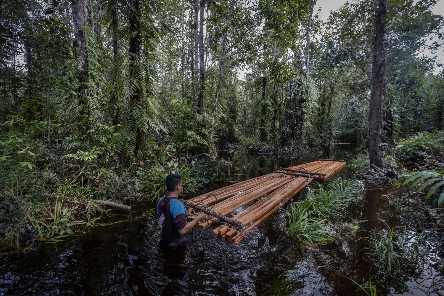
 Central Kalimantan, Dano Tundai, Palangkaraya
A farmer bundles Garuga wood in a forest river—a seasonal activity that provides additional income alongside his main livelihood from farming.
Central Kalimantan, Dano Tundai, Palangkaraya
A farmer bundles Garuga wood in a forest river—a seasonal activity that provides additional income alongside his main livelihood from farming.
Indonesia’s Primary Forest Loss slows in 2024
Central Kalimantan, Dano Tundai, Palangkaraya
A farmer bundles Garuga wood in a forest river—a seasonal activity that provides additional income alongside his main livelihood from farming.
The 2024 Annual Deforestation Update is live on Nusantara Atlas, our independent platform monitoring forest loss across Indonesia, Malaysia, Brunei, Papua New Guinea, and Colombia.
This update focuses on primary evergreen forests, the planet’s most carbon-rich, biodiverse, and ecologically vital terrestrial ecosystems.
Nusantara Atlas tracks both total forest loss and deforestation from oil palm and pulpwood expansion, critical for identifying high- and low-risk suppliers.
Our forest and commodity mapping is based on a novel multi-satellite, multi-temporal approach that integrates radar and optical medium-resolution imagery, deep learning (CNN), and expert visual interpretation. It also incorporates a reliable global Tree Loss Dataset.
New Compliance Tracker
The new Compliance Tracker in Nusantara Atlas helps prioritize land plots, such as concessions, mills, protected areas, villages, based on deforestation that occurred after key regulatory cut-off dates (EUDR, RSPO, NDPE). With 2024 data now available, you can extend compliance checks by another year — bringing the latest evidence into risk assessments and due diligence processes.
Because effective monitoring requires verifiable evidence of every detected forest loss, you can now systematically verify deforestation for any location and time period by automatically generating before-and-after satellite image comparisons — packaged into downloadable PDF report—the next best proof to field verification, ready for use in documentation, audits, or stakeholder engagement.
This eliminates the need for manual image selection. Tasks that previously required hours of expert effort can now be completed in minutes — offering rapid, and visually transparent evidence to support regulatory due diligence and deforestation-free commitments.
The situation in 2024
In 2024, deforestation of primary forests in Indonesia declined by 14%, with 242,000 hectares lost — down from 279,000 hectares in 2023.
Note: A similar trend is observed in other Southeast Asian countries. In Malaysia, 72,781 hectares were cleared, representing a 12% decline. Papua New Guinea saw 30,784 hectares cleared (15% decline), and Brunei recorded 305 hectares cleared (21% decline). In contrast, Colombia experienced a 56% increase in primary forest loss.
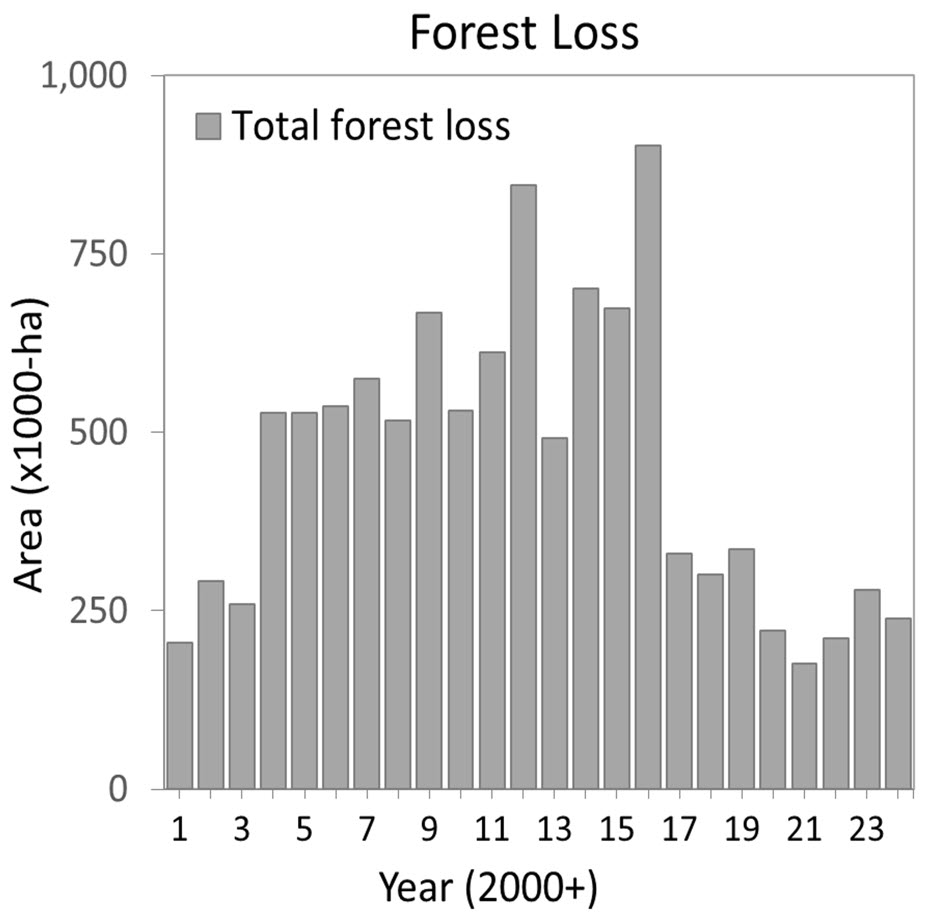
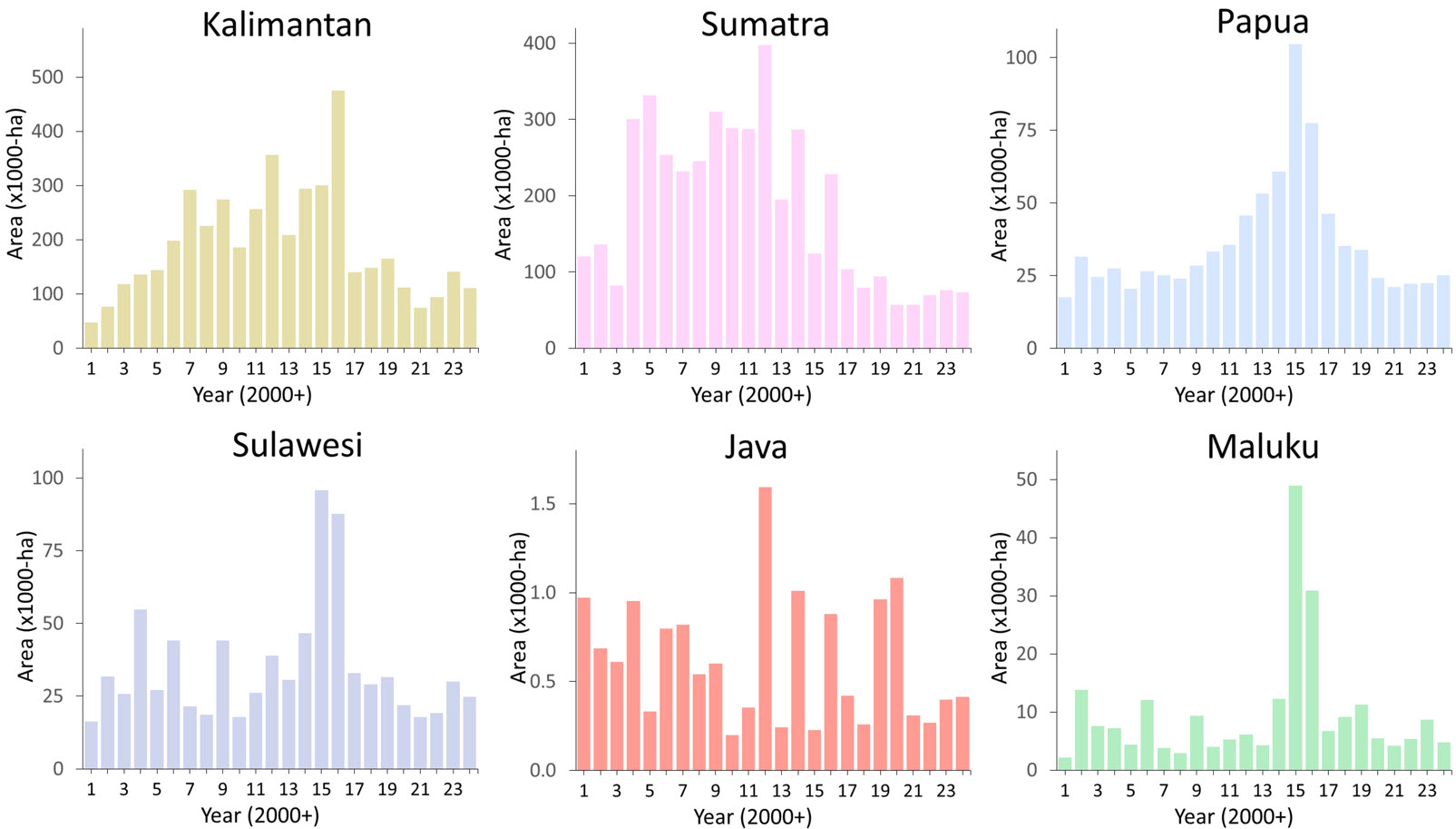
This reduction in deforestation in Indonesia is encouraging, particularly in Kalimantan, Sumatra, and Sulawesi, where forest loss has visibly slowed. However, the pattern reversed in Indonesian New Guinea (Papua), where deforestation rose by 10%, from 22,500 hectares in 2023 to 25,000 hectares in 2024.
Drivers of Deforestation in 2024
Deforestation in Indonesia during 2024 was driven by a mix of industrial expansion, timber extraction infrastructure development, and fire. The following breakdown quantifies each major driver by its share of total deforestation, distinguishing between permanent land-use changes (such as plantations and mining) and temporary ones (like logging and fire). Trends are noted relative to historical averages where applicable.
1. Industrial Oil Palm
Share of deforestation: 13% (31,700 ha)
Type: Permanent
Trend: Below long-term average (21%, 2001–2024)
🔗 See analysis
2. Pulpwood & Timber Plantations
Share of deforestation: 6% (13,300 ha)
Type: Permanent
Trend: Slightly below historical average (10%)
🔗 See analysis
3. Logging (Roads + Tree Felling)
Share of deforestation: 18% (43,559 ha)
Type: Scattered, Temporary
Note: Forests often regenerate after logging
🔗 Reference study
4. Food Estate Projects (New Roads Rice, Sugarcane)
Share of deforestation: 3% (5,914 ha)
Location: Merauke, South Papua
Type: Permanent
5. Forest Fires
Share of deforestation: 2.3% (5,587 ha)
Type: Temporary or permanent
Note: Depends on soil type and burn severity
6. Mining (Coal, Gold, Nickel)
Share of deforestation: ~5% (~12,000 ha)
Type: Permanent
The missing 50%: Idle Land, and Smallholders
The six drivers described above account for roughly half of all deforestation recorded in Indonesia in 2024. So what explains the other 50%?
A significant part of the answer lies in land that is cleared but not immediately used. A study published in PNAS found that large areas of Indonesia’s primary forest are cleared and then left idle for years, with no clear land use. These areas are eventually converted to agriculture—often oil palm—but the long delay introduces major uncertainty about the original drivers and the decision-making behind the deforestation.
Another key gap is smallholder-driven deforestation, associated with crops such as palm oil, corn, rubber, cocoa, and coffee. Detecting this type of land conversion — especially for the most recent period like 2024 — remains a challenge. Our current method, which combines multi-satellite, multi-temporal radar and optical imagery, struggles to identify plantations with open canopies, such as oil palm under 4 years old, or shaded plantations such as coffee and cocoa.
Historically, over the 2001–2019 period, we estimated that smallholder oil palm accounted for around 7% of Indonesia’s total deforestation. With industrial oil palm deforestation falling from a long-term average of 21% to just 13% in 2024, a spike in smallholder-driven clearing seems unlikely, but it cannot be ruled out due to detection limitations.
Additional unknowns include urban expansion, although so far we have not detected deforestation of primary forest caused by the construction of Ibu Kota Nusantara (IKN), Indonesia’s new capital.
Natural disturbances, such as landslides, flooding, and shifting water bodies, also contribute to forest loss, mostly temporary, but these events are not yet systematically captured in our datasets.
We are actively working to improve detection of these smaller, often delayed, land-use transitions. Stay tuned for updates !