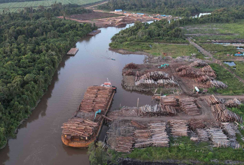
 Logs being loaded onto a barge within a concession operated by Mayawana Persada, a company that nonprofits claim is connected to Royal Golden Eagle. Photo by Greenpeace.
 Industrial Wood Pulp Deforestation in Indonesia Slows in 2024
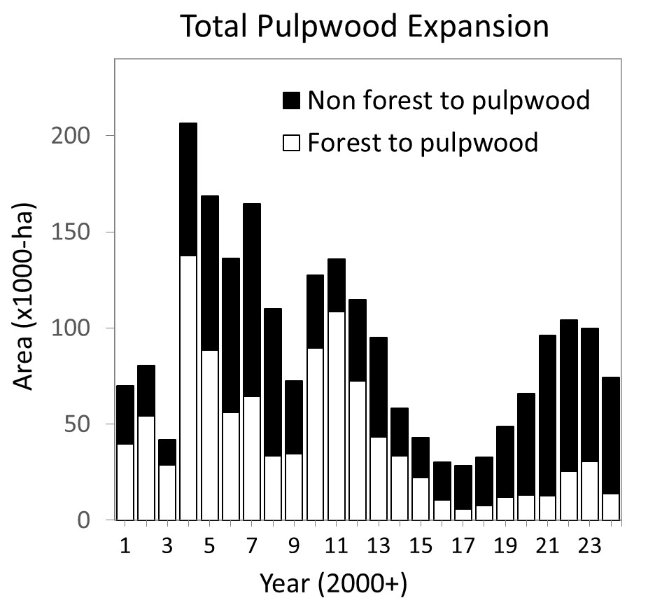
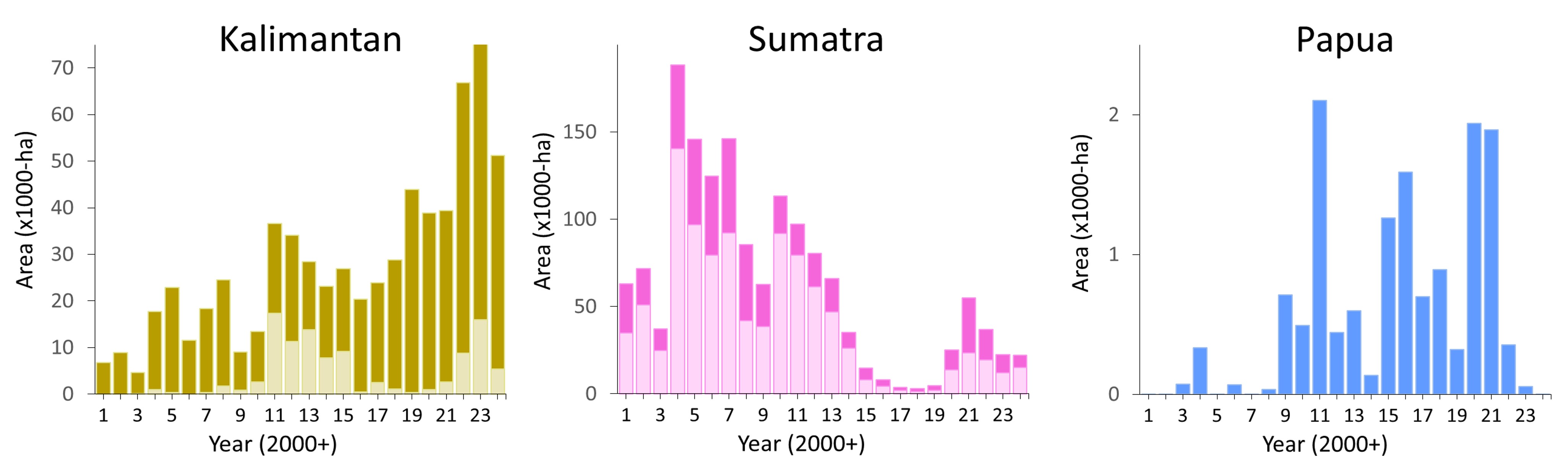
Logs being loaded onto a barge within a concession operated by Mayawana Persada, a company that nonprofits claim is connected to Royal Golden Eagle. Photo by Greenpeace. In 2024, the conversion of old-growth/primary forests* to fast-growing pulpwood plantations (mostly Acacia sp. or Eucalyptus sp.) decreased compared to 2023 (White bars; Figure 1).
Our analysis, conducted using satellite images from Sentinel-2 and Planet/NICFI, reveals that industrial pulpwood plantations expanded by 74,310 ha hectares in 2024 (White and black bars; Figure 1), a 25% decrease from the previous year. The associated deforestation also declined by 55%, with 13,647 hectares of forest converted in 2024 compared to 30,385 hectares cleared in 2023.
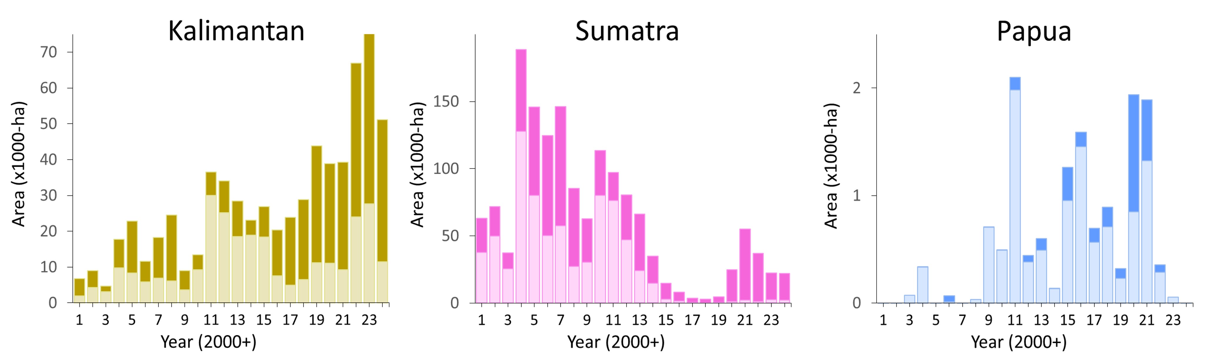
Regional analysis shows a decline in plantation expansion (light and dark bars) and associated deforestation (light bars; Figure 3) in Kalimantan and Sumatra and Papua.
Notably, 42% of the pulpwood-driven deforestation in 2024 took place in just two concessions: Mayawana Persada and Industrial Forest Plantation.
Mayawana Persada alone accounted for 33% of the deforestation, highlighting its disproportionately large impact.
Tables 1 and 2 present a comprehensive list of companies involved in converting forests and peatlands into industrial wood pulp plantations in 2024. Each of these companies is catalogued in the Nusantara Atlas, where users can view satellite animations to independently verify the changes.
| No | Company Name | Group | Concession (Ha) | Province | Deforestation | ||
| 1 | Mayawana Persada | Alas Kusuma | 138,809 | West Kalimantan | 4,538 | ||
| 2 | Industrial Forest Plantati0N | Nusantara Fiber | 101,416 | Central Kalimantan | 1,239 | ||
| 3 | Sendawar Adhi Karya | 24,077 | East Kalimantan | 862 | |||
| 4 | Indosubur Sukses Makmur | 28,215 | East Kalimantan | 386 | |||
| 5 | Buana Megatama Jaya | 43,111 | West Kalimantan | 377 | |||
| 6 | Hutan Berau Lestari | 12,298 | East Kalimantan | 374 | |||
| 7 | Swadaya Perkasa | 16,694 | East Kalimantan | 357 | |||
| 8 | Muara Sungai Landak | 11,847 | West Kalimantan | 305 | |||
| 9 | Andalan Karya Pertiwi | 29,071 | Kepulauan Bangka Belitung | 254 | |||
| 10 | Meranti Laksana | Meranti Laksana | 18,460 | West Kalimantan | 217 | ||
| 11 | Intraca Hutani Lestari | 41,611 | North Kalimantan | 207 | |||
| 12 | Jaya Bumi Paser | 23,597 | East Kalimantan | 201 | |||
| 13 | Hutan Rindang Banua | Sinar Mas Group (UFS-DSS) | 247,618 | South Kalimantan | 170 | ||
| 14 | E-Grenndo | 14,613 | Central Kalimantan | 137 | |||
| 15 | Fajar Wana Lestari | 17,697 | West Kalimantan | 132 | |||
| 16 | Wana Hijau Pesaguan | Djarum | 80,147 | West Kalimantan | 104 | ||
| 17 | Perawang Sukses Perkasa | Sinar Mas Forestry Affiliated | 6,361 | Riau | 87 | ||
| 18 | Wahana Agro Mulia | 30,893 | South Sumatera | 77 | |||
| 19 | Duta Andalan Sukses | 20,533 | West Kalimantan | 65 | |||
| 20 | Bumi Hijau Prima | 10,969 | Central Kalimantan | 61 | |||
| 21 | Kalpika Wanatama Unit Ii | Barito Pacific | 54,231 | South Maluku | 60 |
| No | Company Name | Group | Concession (Ha) | Location | Clearing on peat (Ha) | ||
| 1 | Mayawana Persada | Alas Kusuma | 138,809 | West Kalimantan | 3,398 | ||
| 2 | Bumi Mekar Hijau | Sinar Mas Forestry Affiliated | 250,272 | South Sumatera | 1,512 | ||
| 3 | Buana Megatama Jaya | 43,111 | West Kalimantan | 1,444 | |||
| 4 | Paramitra Mulia Langgeng | 70,201 | South Sumatera | 501 | |||
| 5 | Muara Sungai Landak | 11,847 | West Kalimantan | 381 | |||
| 6 | Riau Andalan Pulp & Paper | RAPP owned concession | 338,228 | Riau | 183 | ||
| 7 | Arara Abadi | Sinar Mas Forestry | 296,058 | Riau | 176 | ||
| 8 | Wahana Lestari Makmur Suks | RAPP open market suppliers | 13,860 | South Sumatera | 111 | ||
| 9 | Mitra Hutani Jaya | Sinar Mas Forestry Affiliated | 9,715 | Riau | 74 | ||
| 10 | Bumi Andalas Permai | Sinar Mas Forestry Affiliated | 189,529 | South Sumatera | 69 | ||
| 11 | Sumatera Riang Lestari | RAPP supply partner | 106,627 | Riau | 43 | ||
| 12 | Tiesico Cahaya Pertiwi | 4,678 | South Sumatera | 30 | |||
| 13 | Tri Pupajaya | Sinar Mas Forestry Affiliated | 21,583 | South Sumatera | 27 | ||
| 14 | Sumber Hijau Permai | Sinar Mas Forestry Affiliated | 30,055 | South Sumatera | 26 |
*Our definition of ‘Primary forest’ includes intact primary forests as well as primary forests that have been degraded by selective timber harvesting during the 1980s and 1990s. Intact forests have not been severely disturbed by humans in recent decades, or disturbances were too old to be detected by the satellites. Selectively logged forests include forests that have been impacted by both artisanal tree cutting as well as by more extensive mechanized timber cutting and extraction. A comparison against available above-ground biomass and tree height maps indicates a mean ± SD above-ground carbon of 116 Mg C/Ha and mean ± SD tree height of 28 ± 11 metres for ‘Primary forests’. Intact and selectively logged forests are similar to “primary” and “secondary” forests on the Indonesian Ministry of Forestry and Environment’s forest maps. Our definition of “forests” excludes young forest regrowth, agro-forests, mixed gardens, scrublands, tree plantations, agricultural land, and non-vegetated areas.