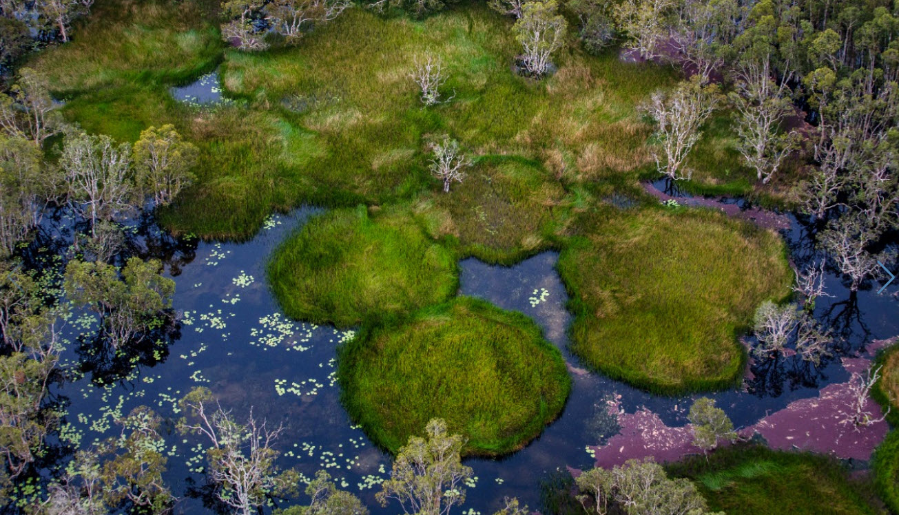
 Aerial view of a natural wetland landscape composed of Melaleuca swamp forest, marshes, open water bodies, and seasonally flooded grasslands. Large areas of these relatively intact landscapes fall within the footprint of the 2.32 million-hectare South Papua National Strategic Project (PSN). Photo by Ulet Ifansasti/Greenpeace
 Inside Indonesia’s Largest Agricultural Expansion Project: The 2.3 Million-Hectare Plan Transforming South Papua
Aerial view of a natural wetland landscape composed of Melaleuca swamp forest, marshes, open water bodies, and seasonally flooded grasslands. Large areas of these relatively intact landscapes fall within the footprint of the 2.32 million-hectare South Papua National Strategic Project (PSN). Photo by Ulet Ifansasti/Greenpeace • Nusantara Atlas now hosts a reconstruction of Indonesia’s South Papua National Strategic Project (PSN) plan, revealing a 2.32 million-hectare development zone spanning rice, sugarcane, oil palm, pulpwood, a Food Estate road and logistics port in Merauke regency.
• While only 40,000 hectares have been cleared so far, the plan’s vast footprint suggests the potential for far greater transformation. Nusantara Atlas enables anyone to monitor future deforestation, fires, plantation expansion, road construction, and port development across Indonesia’s largest agricultural expansion initiative.
Merauke, this regency of South Papua province, remains largely intact and sparsely populated due to its remoteness, tropical savanna climate with prolonged wet and dry seasons, and strong Indigenous presence. It is characterised by a diverse mosaic of wetlands, Melaleuca swamp forests, natural grasslands, wooded savannas, and primary rainforests, including mangroves, lowland rainforests, and peat-swamp forests. But its inclusion in Indonesia’s National Strategic Projects (PSN) is changing that. Backed by national interest, and supported by army personnel, the PSN project benefits from fast-tracked permits, minimal oversight, and a powerful development mandate.
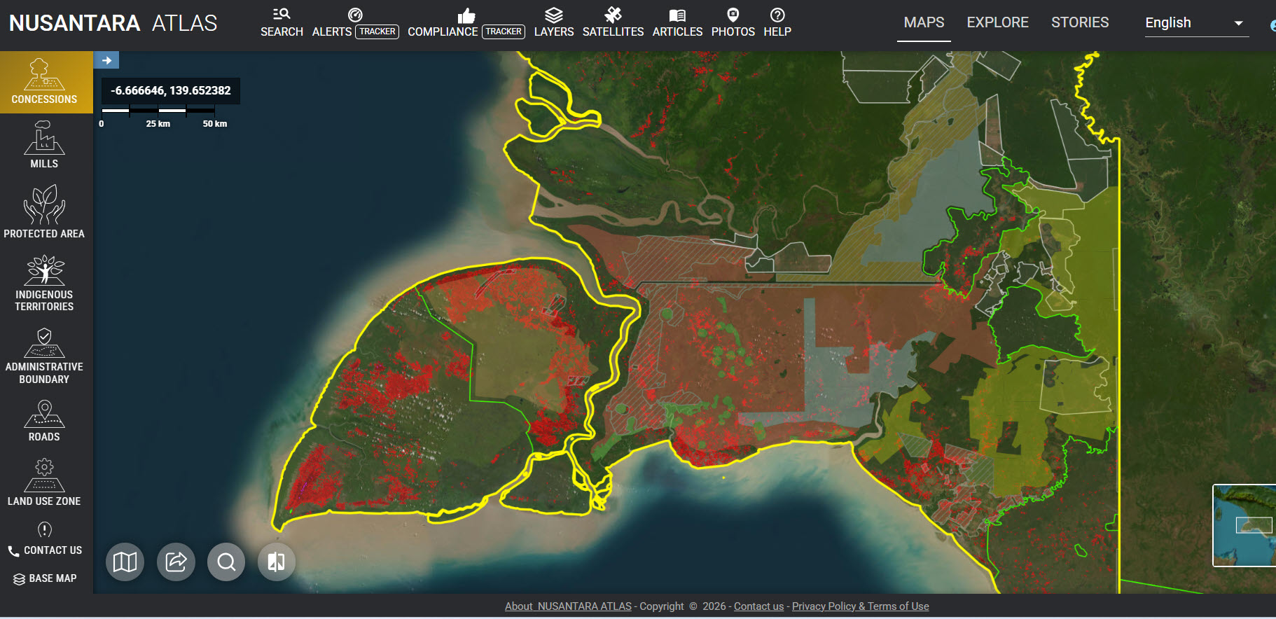
Indonesia’s South Papua National Strategic Project (PSN) is dubbed the “world’s largest planned land clearing initiative“. By integrating spatial data from multiple Indonesian ministries and government agencies, in collaboration with Yayasan Pusaka, we produced a detailed reconstruction of the South Papua PSN.
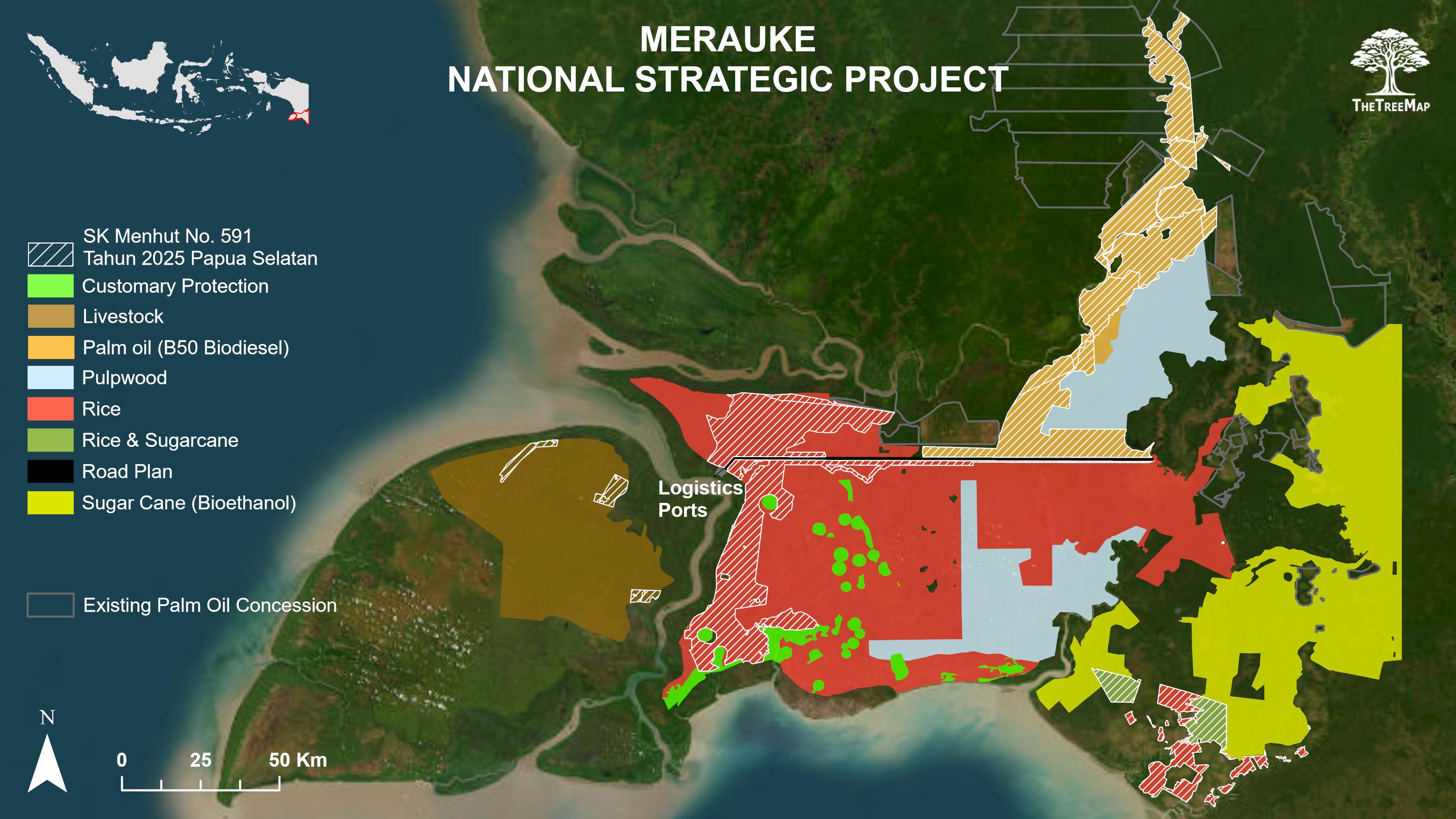
This reconstructed PSN landuse plan is now available to visualise interactively on Nusantara Atlas (see also this video tutorial below). The project spans 2.32 million hectares, showing the planned locations of rice fields, sugarcane plantations, oil palm developments, pulpwood estates, roads, and ports. Users can explore real-time deforestation data in the project boundaries, verify planned land allocations, infrastructure corridors, and associated companies and concessions. The reconstruction can be overlaid with the latest high-resolution satellite imagery, historical Landsat and Sentinel archives, deforestation alerts, burned area maps, protected areas, and Indigenous territories. Users can also generate time-lapse animations documenting landscape change over time, making it possible to monitor the construction of roads, ports, plantations, and other infrastructure as the project unfolds.
The reconstruction reveals a landscape allocated to multiple strategic objectives linked to Indonesia’s food and energy self-sufficiency agenda. Large areas have been designated for rice cultivation, with the government aiming to establish up to one million hectares of new rice fields in Merauke to strengthen national food security and reduce dependence on imports. Our map indicates that 882,000 ha have been allocated to rice production (red).
The map also identifies extensive areas planned for sugarcane plantations (531,471 ha; yellow), intended to supply Indonesia’s emerging bioethanol industry and support efforts to reduce reliance on fossil fuels.
In addition, 228,411 ha have been allocated for oil palm development to support the B50 biodiesel programme (orange), complementing existing palm oil plantations (260,482 ha) in the region and increasing the share of palm oil in Indonesia’s transport fuel mix. A further 272,482 ha are designated for livestock production. Other planning documents in Neighboring district suggest the final oil palm allocation could exceed 400,000 ha, underscoring that the South Papua PSN is evolving.
The reconstruction includes large areas designated for pulpwood plantations supplying the pulp and paper sector. Many of these concessions predate the current PSN initiative but, we have incorporated them into the broader development framework of the PSN project.
Importantly, the reconsturction highlights, in dashed lines, the area covered by Ministerial Decree from Forestry (SK Menhut No. 591/2025), which reclassified 486,939 hectares of State Forest (Kawasan Hutan) as non-forest land (Areal Penggunaan Lain; APL) to support the development of this National Strategic Project (PSN). This rezoning provides the legal basis for large-scale agricultural and infrastructure development within the project area, reclassifying nearly 300,000 ha of primary closed-canopy forest for potential conversion. However, this decree has been challenged by Indigenous communities, including the Marind people, who argue that it threatens customary territories and was adopted without adequate recognition of Indigenous rights and consent. According to our reconstruction, just 55,335 ha have been allocated to Customary protection (green on the map) by the Government in Jakarta.
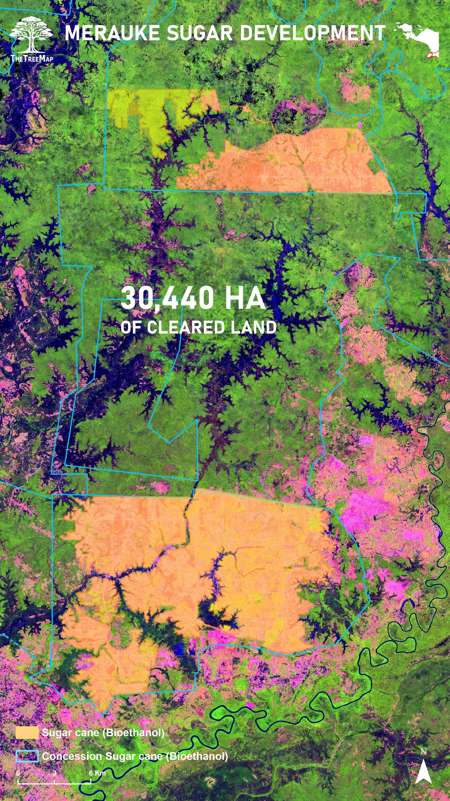
Recent satellite analysis indicates that implementation is already underway. Since the launch of the project, over 30,440 hectares of forests and savannas have been cleared for sugarcane development, encroaching directly with the territory of Ye Indigenous Peoples, along the border with PNG.
PT Global Papua Abadi (GPA): Operating on ~50,000 ha, cleared 22,006 ha of land between Jan 2024 and December 2025. Investigations by Pusaka link GPA’s director and Sulaidy to the Fangiono family.
PT Murni Nusantara Mandiri (MNM): Operating on 52,000 ha, cleared 8,285 ha during the same period, also a mix of primary forest and wooded savanna. MNM borders Bupul Nature Reserve and is likewise tied to the Fangiono network, according to investigations by Pusaka.
Supported by new infrastructure investments and the legal conversion of State Forest to non-forest land uses, seven additional concessions could soon become active. In total, around 500,000 hectares are slated for sugarcane development, posing an unprecedented threat to one of Indonesia’s largest remaining forest–savanna landscapes.
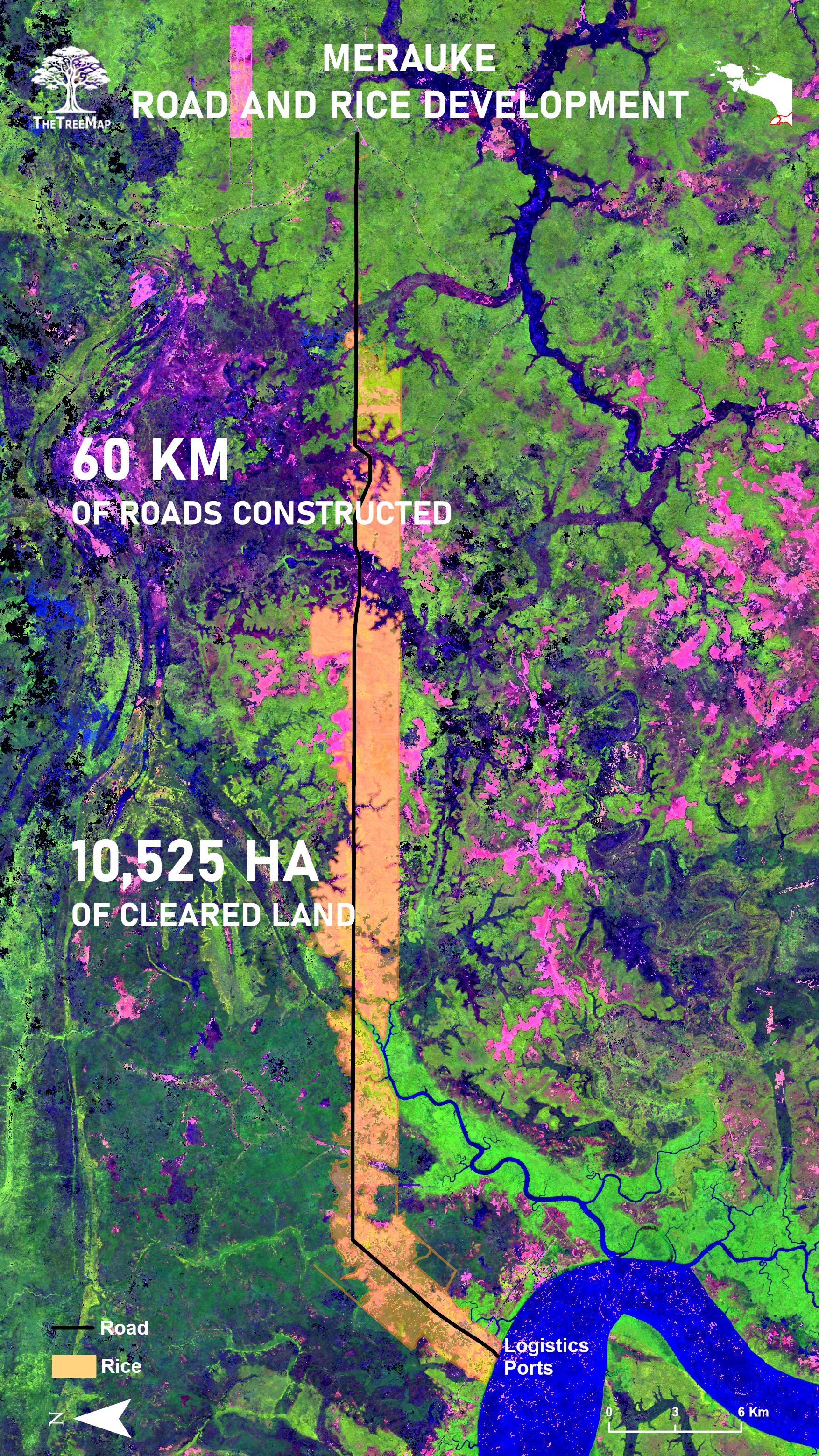
An additional 10,525 hectares have been converted for rice cultivation and road construction in the villages of Wanam, Wogikel and Salam Epe.
Supporting infrastructure forms a central component of the project. The map delineates a planned 135-km food estate road corridor connecting Wanam and Muting, intended to facilitate access to agricultural production areas, processing facilities, and logistics hubs. Our satellite analyses indicate that 60 km of this road network have already been opened by Jhonlin Groug, increasing access to previously remote landscapes. Once completed, the road is expected to connect with the existing MIFEE and Trans-Papua road networks, potentially accelerating land-use change across the region.
Marind Indigenous people from the south Papua recently filed a legal challenge against this road planned to facilitate a government National Strategic Project (PSN) to convert their tropical forest, savannah and wetlands into rice paddies and oil palm plantations in Merauke district.
The map also identifies the planned Wanam logistics port, a strategic piece of infrastructure designed to support the export and distribution of agricultural commodities produced within the PSN. The port is expected to facilitate the transport of rice, sugar, bioethanol, palm oil products, and other commodities from Merauke to domestic and international markets, reducing logistical constraints associated with large-scale agricultural production in this remote region.
The South Papua PSN remains in its early stages of implementation. The 40,000 hectares cleared so far for sugarcane and rice development represent a small fraction of the project’s 2.32 million-hectare footprint. Whether the full extent of the planned developments ultimately materialises remains uncertain and will depend on political priorities, environmental and economic conditions, infrastructure development, investor interest, and resistance from affected communities.
Whatever its final extent, the South Papua PSN has already set in motion a period of profound transformation. Whether the project ultimately achieves its agricultural objectives remains uncertain given Merauke’s seasonal droughts, flooding, and challenging soils.
At the same time, the planned expansion of roads, drainage systems, and land clearing will increase fire risk in a landscape that already experiences frequent burning every year during the dry season. Between 2019 and 2025, 407,117 ha burned in Merauke alone, including 169,903 ha within the 2.32 million-hectare PSN footprint, based on the methodology published in our PLOS ONE paper and updated to 2025.
Experience from previous large-scale land development projects in Indonesia has shown that draining natural wetlands and converting natural vegetation substantially increase the frequency, extent, and severity of forest and land fires, making them more difficult to control and farm. If similar processes unfold in South Papua, the region will face a lasting legacy of elevated fire risk, environmental degradation, increased greenhouse gas emissions and air pollution, biodiversity loss, and social and human rights impacts.
To enable transparent monitoring of these changes, the reconstructed PSN land use plan is now publicly available through Nusantara Atlas. Users can explore the project alongside high-resolution satellite imagery, historical Landsat and Sentinel archives, deforestation and fire alerts, concession boundaries, protected areas, and Indigenous territories, as well as generate time-lapse animations documenting landscape change over time. With El Niño conditions expected to intensify through late 2026, such monitoring will be particularly important in Merauke, from July to November, where fires are a recurrent feature of the forest–savanna–wetland landscape.
At the same time, Indigenous communities are increasingly asserting their voices in the debate over the future of Merauke. Through legal challenges, advocacy campaigns, and cultural initiatives such as the documentary Pesta Babi, Marind and Ye communities and their allies are drawing national and international attention to the environmental, social, and cultural implications of transforming one of Indonesia’s largest remaining forest, wetland, and savanna landscapes.